| Where's That Control Point? |
||||||
Author American River College, Geography 350: Data Acquisition in GIS; Fall 2003 j_boldman007@yahoo.com | ||||||
Abstract The National Geodetic Survey maintains a nationwide network of control points, also known as bench markers. Often these are used as the basis for surveys, property lines, and other uses that require accurate horizontal and vertical data. The author in this paper intends to seek out these control points and discuss how easy they are to find. Methods will be described on how the find the points using a combination of GPS and the Internet. Also the author will address how the given coordinates can vary from actual coordinates. |
||||||
Introduction How does one find a 3-inch disk implanted in the earth? Control points have been placed by numerous organizations including the National Geodetic Survey for accurate horizontal and vertical coordinates for anyone who might have a use for them. In some instances you might have plenty of time to find them, but other times you may not. This paper answers the question how easy is it to find these little disks.
|
||||||
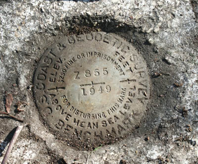
Background The National Geodetic Survey maintains a network of control points to be used for many purposes. Some of these include surveying, mapping, transportation and other navigational needs, engineering needs, monitoring obstructions to navigation on land, sea, or air, and aerial photography. The NGS also ensures that the data that it collects meets standards for accuracy. (NGS, 2000). Many of the control points monumented by the NGS consist of a small disk or mark on the ground with NGS printed on it and maybe a couple of numbers. Nearby there are often reference marks. If you get the coordinates of a control point at the site, you can research it online or vice versa. This data can be used for numerous mapping applications. Legally in a dispute, an established control point holds legal priority over a freshly created one. It has been around longer than the dispute, thus avoiding any question of tampering or bias in its creation. Control points are also used as a starting point to survey land for building new lots of property and roadways (Mills, 2003). Control points also provide a good reference for elevation studies. Since the point’s altitude is known at a certain time, it can be used as a guide for monitoring changes over time. A recent study found that Louisiana’s coastal marshes are subsiding. This was ascertained by monitoring the elevation at set control points over time. Data from this study is going to be used to develop plans to ensure that communities don’t sink and more importantly plan for future hurricanes, hopefully saving lives (Laborde, 2003). At Kilauea, an active volcano in Hawaii, the USGS uses bench markers to monitor the rise in elevation of the caldera. A positive change in elevation implies that magma is rising beneath the surface, indicating a possible eruption, while deflation and the reduction of activities is seen with a negative change in elevation (USGS Hawaii, Internet). These bench marks provide valuable information about the working of an active volcano. Often a control point will be tampered with by a rebellious citizen, built over by a new construction project, or will lose the battle against the wrath of nature. Common natural threats include frost, soil expansions, erosion and/or instability (Wisconson, Internet). With over 700,000 reference marks and control points across the nation, it is relatively impossible with temporal and financial constraints to monitor these points (Geocaching, Internet). To save themselves work, they allow private users or other citizens to submit recoveries of these points online. Logging on to the NGS website and by filling out a form, which they will review and post on the online data sheet. This allows users of the control points to know which ones are possible to be found, and allows the NGS to spend more time on other projects and control point repairs. 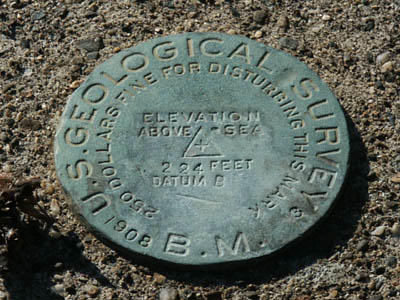
|
||||||
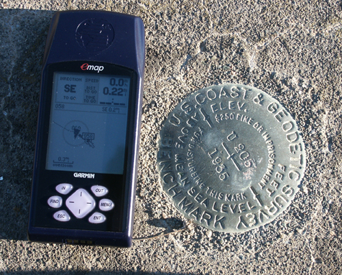
Methods While serendipity can sometimes strike and one can find a control point by accident, if you are seeking a NGS station control point, the only simple reliable way to find them is the Internet. At the National Geodetic Survey’s website, if you click to the datasheet retrieval page (http://www.ngs.noaa.gov/cgi-bin/datasheet.prl) you will find multiple ways to search for a control point. Search options include permanent ID numbers, which are only useful if you already process the PID (these are often not found at the actual control point). Another search method is by coordinates, if you want to find all nearby control points to a certain location using longitude or latitude. Other methods to search by USGS quads, county, or control point name. Lastly, you can search using an interactive map. A graphic of this map follows... Another resource is the website for geocachers (a GPS game). They have a listing of bench markers from the NGS. I would recommend this as an extra step. Often geocachers might have visited bench markers, and you might find additional hints on where the location is. Many of the recoveries of the control points occurred over 20 years ago, and a lot might have changed in the location. After I have gathered my data, it was time to hop in the car, crank up the tunes, and visit these control points. My standard procedure was to use my Garmin Emap handheld GPS acquired in 2000 to find the coordinates of the points. Previously I used online maps or memories to drive near to where I was going to look. When I got there, I looked around until I found the points, unless I had to leave because of time or weather constraints. Upon finding the points, I used my Minolta Dimage 7i camera to document them. My results section contains more detailed descriptions of my hunts. After returning, you can then go online, and let the USGS know if you recovered the control point. All you need is the reference number and some photographic evidence. 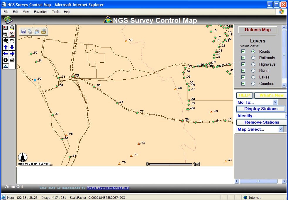
|
||||||
Results
In total, seven control points were found, and a few more remained hidden. One control point that was found was a silo on a barn that was located a few hundred feet from the road. The rest that were found were disks embedded into concrete. When the disks were found, most were clearly visible, one had to have moss removed from it. A point in the side of a building in Folsom was painted over, blending in well to its surroundings. A few points had survey flags nearby, showing recent usage. The real challenge is to actually find the control points. On many control points, the coordinates that were acquired online were off by a couple of hundred of feet, or in a few cases over 2000 feet. This made it harder to find a couple, however the descriptions from the NGS website helped out with the search. This played a bigger factor than errors from using NAD 83 coordinates in a WGS 84 equipped GPS. Both datums are off only by a few meters (DoD and DoT, 1994). Searching is not always a walk in the park. Many of the control points were on private property, requiring permission to access. With the inaccuracies in the coordinates, it is easy to search in the wrong area and not realize that the point that is sought cannot be found in the search area. As one finds more points, one will likely rely less on GPS coordinates than on old-fashioned sleuthing skills. Many hazards await the control point recoverer. One point was located near a local hunting and trap club. Uneven terrain must be traversed ranging from railroad tracks to weedy hills, to muddy rock outcroppings. At one point the author's GPS fell from his pocket to the ground 15 feet below a rock outcropping, fortunately it sustained only minor scratches. On the railroad tracks, shotgun casings were found, while a flock of red-winged blackbirds flew overhead. JS0720: Folsom, near a rock outcropping southwest of the Rainbow Bridge. JS0721: Folsom, on the foundation of a building at the intersection of Riley and Sutter. JT0245: near Sonoma, along the Union Pacific Railroad. Southeast a few miles of Schellville. JS0813: Folsom, in a graveyard near a catholic church. JS4815: Folsom, near the intersection of Folsom Blvd. and Blue Ravine road. JS4112: Citrus Heights, along Uplands drive, southwest of Sunrise. For more information on finding the control points, pictures, and NGS datasheets see the appendix section. |
||||||
Table of Results
The first row gives the PID number for the control point. The "Given" row is the actual coordinates given by the National Geodetic Survey's datasheet in NAD 83. The third row is coordinates that I took from the site in WGS 84, followed by a rough distance estimate from the GPS. This is followed by my observations on the visability of the satellites from the locations. Date placed is the date that the control point was monumented, while the last recovery is the last time that a recovery was posted on the NGS website. |
||||||
 |
||||||
Analysis
One of the major things that I have learned is not to rely solely on coordinates. The markers in Folsom and in Sonoma County, I found more based on the description than the coordinates themselves. Since the difference between NAD 83 and WGS84 is minimal, just meters, the differences that I have between the actual and the provided coordinates are not caused by that. All but one of the control point’s horizontal coordinates were off by over a thousand feet. This is surprising. I had thought that the differences would be along the lines of maybe a few hundred feet, accounting for my GPS, the built in system inaccuracies of the GPS satellites, and error on the NGS on the coordinates. These offsets, would make this data unreliable for usage, in most applications, except small-scale mapping, that does not require the accuracy. On some of the data sheets I read that the coordinates were taken from a topographic map, leaving open numerous ways to inaccuracy. The point might not be mapped in its true position, the measurer could have made a mistake, or a few other ways could have lead the coordinates astray. To test out the accuracy of my GPS, I tried it out with a few of geocaches. A geocache is like a bench marker in that it is to be found by exact geographic coordinates that can be found online. With finding a few geocaches, my GPS was able to get me within about 100 feet, some even as close as 20 feet, of the actual cache. I felt that this ruled out most of the error from my GPS. However, these coordinates were in WGS 84, the same as my GPS. Due to the inaccuracy of low-level GPS receivers, I decided against checking the vertical control on these points. Visibility did not also appear to play much of a difference in my findings. Two sites with excellent visibility were over a thousand feet off, while one that had very good visibility was less than 200 feet off. Age of monumentation does not also appear to make a difference. The only point with accurate coordinates, was monumented in 1975, about middle of the road of the ones I studied. This one was readjusted in 1998 according to the data sheet. It also has two reference marks nearby that lead to it. Ones from the early 1900's and the 1990's were both over a thousand feet off. Both a recent and an older control point both had distances from given to actual of over 2000 feet off. |
||||||
Conclusions
As I have discovered, finding an accurate control point as a starting point for a survey can be a challenge. Many of the points that I found, the coordinates were far off from the given data. Any data based on one of these control points will be less reliable and not fit in as well with existing map data. The user can run into numerous conflicts of data and projections, requiring another trip into the field or reestablishing the whole survey. If the actual coordinates (by GPS receiver readings) are different at a control point than the given, would it not be the same as using a newly created control point? There are numerous advantages in using pre-established data. One is a higher precedence in court proceedings about land disputes. However, in many cases with the advent of more accurate GPS receivers and with the unscrambling of the GPS signal for civilian usages, it might be better and less costly to establish a new control point. With the coordinates, I found no real pattern based on age or visibility on the difference between the NGS coordinates and the ones I gathered in the field. There are two likely sources of error. One is that the coordinates given by the NGS were off in whatever way they were gathered by old field work, before modern technology or they might have been taken off of topographic maps, which was indicated on one of the NGS data sheets. There is a note on the datasheets advising of a ± 6 second error which might be found with coordinates derived from a topographic map. Five of the points that I found were taken off of topographic maps, accounting for the error. Most were southeast of the actual coordinates. Others I could not find, so I am not sure on the accuracy of those, due to not having the actual coordinates. The other source of error is my GPS. While I checked it with a couple of geocaches and it was accurate, there might have been some unforeseen problems with coordinates being translated from NAD 83 and WGS 84. Another problem that I encountered was the inability to find many of the control points. Some will be rectified by acquiring permission to enter the private land that they rest on. Others, I felt a more though search would have turned up the bench marker, but time or conditions did not make it feasible. For finding a marker, the most efficient way is to read the NGS description on the datasheet and look for any additional insight at the geocachers website. Upon entry into the field, the GPS can be used to close in on the position. Once there, the most reliable instrument still is the human eye to find the control points. For further study, I would continue to visit different control points and take GPS readings and compare with the NGS. I would try to visit a variety of points, emphasizing points that were not just taken from topographic maps, to test for accuracy and try to find a clearer pattern. Also I would upgrade my GPS to ensure a better match of coordinates. In addition, I submitted recoveries for JT0245 and JS4815 to the NGS using their online form . . 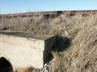 JT0245 in its natural setting. |
||||||
“Benchmark Hunting” www.geocaching.com. Internet. Department of Defense and the Department of Transportation. United States. 1994 Federal Radionaviagation Plan. Appendix B: Reference Systems. http://www.navcen.uscg.gov/ftp/GPS/archives/gpsdoc/frp1994/12APXB.PDF Laborde, Kent. NOAA-LSU Study: Portions of Gulf Coast Sinking at Significant Rate. April 16, 2003. http://www.noaanews.noaa.gov/stories/s1128.htm Mills, Chad. “Washington Monuments: Creating a Web-Based Warehouse for Survey Control Data” GeoWorld. October 2003. Online at www.geoplace.com USGS: Hawaiian Volcano Ovservatory. “How Hawaiian Volcanoes Work” http://hvo.wr.usgs.gov/howwork/subsidence/inflate_deflate.html Wisconsin State Cartographer’s Office. “Surveying and Geodetic Control” Internet. http://www.geography.wisc.edu/sco/geodetic/ All other data courtsey of the National Geodetic Website including all data sheets. http://www.ngs.noaa.gov |
||||||
During my work on this project, I noticed that there was a definite pattern to the distribution of control points in the Sacramento Region. They are heavily clustered towards the railroads and a few certain surface roads like Greenback. A map of this is seen in the picture gallery in Appendix 3. I thought that this was a very interesting observation and it led me to wonder how old some of these control points were. The railroads have been around here for a long time and likely the control points were used to find the land that the railroads owned. Later on, I noticed that the older control points had less accurate coordinates than the newer ones. I decided to take a random sample of Sacramento control points to see what the average age might be. From the Sacramento map I used random numbers to pick out 56 control points out of the total population. I then got the year that each point was monumented and the coordinates gotten and averaged them out. The average of this sample is 1952 as the year of creation. This is only the average of the sample, not the true average, which includes all control points. Using proper statistics procedures, I am 95% confident that the true average year of creation for Sacramento control points is between 1946 and 1958. Appendix 2: Selected Control Point Datasheets.
|
||||||